
Why Early-Stage Evidence Now Decides Planning Outcomes
The Environment Agency’s National Flood and Coastal Erosion Risk Assessment 2024 shows that about 6.3 million properties in England already fall inside a flood risk area. Storms Babet, Ciarán and Debi then pushed weather related home insurance claims to a record £573 million in 2023.
In pre-application meetings, Lead Local Flood Authorities open with a single request: ‘Illustrate the flood depths as risks before we consider your layout’. If a designer combines pipe hydraulics with surface flow in a traditional spreadsheet delivery, several days – and considerable goodwill – are lost before a concept can be priced.
What the ‘ML Deluge’ Tool Provides for your Designs
Autodesk’s Machine Learning Deluge routine builds a first flood-depth mesh, as soon as you load the ground model and choose a design storm profile (FEH 13, ReFH 2 or legacy FSR).
Because the engine combines pipe locations and networks with realistic surface areas in the same calculation, the adjustment of a single manhole invert immediately updates surcharge tables and flood extents at the same time.
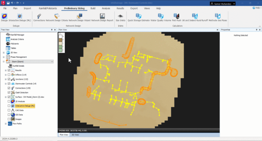
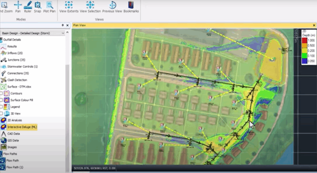
- Live ‘what if’ design – click to place a retention basin, swale or raised verge and the map recolours in seconds, so stakeholders see the hydraulic impact while options are still on the table.
- Export on demand – depth grids publish straight to DWG, SHP or geoTIFF for CAD overlays or for stakeholder engagement.
- Build-in climate uplift – FEH and ReFH storms can be run with the latest Environment Agency allowances without external look-up tables.
A 5-Step Starter Recipe
- Import topography – Civil 3D surface, LandXML, or ASCII grid.
- Add the baseline network – drag manholes and pipes or read from CSV or DWG.
- Run ML Deluge – choose the one hundred year plus climate change storm and review baseline depths.
- Iterate controls – detention pond, swale or permeable pavement. Use undo and redo to compare footprints.
- Generate a stakeholder pack – one click PDF with the flood map, legend and return period notes.
What Planners and Designers Gain
Planning officers receive a colour coded flood extent tied to officially recognised storms, so drainage questions are settles in the first review round. Designers spend time on true option-based engineering rather than using older processes such as schedule manipulation and data interrogation, and architects can agree building footprints earlier with confidence that run-off will flow to the intended outfall.
Therefore, ML Deluge converts flood risk unknowns into real-time graphics that win trust at pre-application stage, and keep projects moving towards swift approval.
Still got Questions?
Book Training
Our Autodesk InfoDrainage training will teach you how to navigate the interface, build a drainage system and design pipes, import and export data, pond and suds design as well as flooding simulation.
Contact Us
We are here to ensure you receive a consistently high service and quality solutions for your business needs. We promise you won’t regret speaking to us, and if we can’t help you, we will try to find someone that can.